
 15 Topics
 5 Days
 60 Sessions
Programme Overview
Training Description
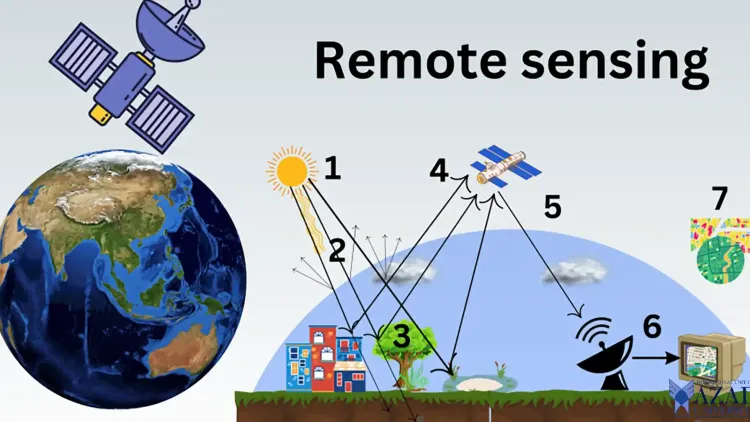
In today’s fast-paced world, the use of satellite remote sensing technology is becoming increasingly vital for monitoring and evaluating environmental and socio-economic projects. This course on Satellite Remote Sensing for Impact Assessment & Project Evaluation provides comprehensive knowledge and practical skills to leverage satellite data for assessing project impacts. Whether monitoring the effectiveness of development projects, tracking land use changes, or evaluating the effects of natural disasters, satellite remote sensing offers precise, cost-effective, and timely insights.
By utilizing high-resolution imagery and advanced analysis techniques, this course will empower professionals to make data-driven decisions, leading to improved project outcomes and sustainability. Participants will gain proficiency in processing satellite images, analyzing environmental data, and understanding how remote sensing can be integrated into impact assessments and project evaluations.
Session Objectives
- Understand Satellite Remote Sensing Fundamentals: Gain an in-depth understanding of the principles and technology behind satellite remote sensing and its role in project evaluation and impact assessment. Acquire Image Processing Skills: Learn to process satellite imagery using industry-standard tools and software (e.g., Google Earth Engine, QGIS, ArcGIS) for environmental monitoring and project evaluation. Analyze Environmental Changes: Understand how to use remote sensing data to detect and assess environmental changes such as deforestation, urban sprawl, and agricultural productivity. Integrate Remote Sensing with GIS: Learn to integrate remote sensing data with Geographic Information Systems (GIS) to perform spatial analysis for evaluating project impacts. Evaluate Project Effectiveness: Develop the skills to assess the success of environmental, infrastructure, and socio-economic projects using satellite data, and link remote sensing findings to project goals. Master Change Detection Techniques: Learn how to apply advanced change detection techniques to monitor the progress or failures of projects over time, using temporal satellite imagery. Enhance Reporting & Visualization Skills: Acquire skills to visualize and report the results of satellite-based assessments to stakeholders, improving communication of findings. Improve Decision-Making: Learn how satellite remote sensing data can improve decision-making in project planning, implementation, and evaluation, ensuring more sustainable outcomes. Stay Updated with Emerging Technologies: Understand the latest trends in remote sensing technologies and their applications for monitoring, evaluation, and impact assessment. This course is designed to provide hands-on experience with remote sensing tools and satellite data analysis. It is structured to offer a thorough understanding of how satellite imagery can be used for precise and scalable project evaluations, ensuring participants are equipped to deliver valuable insights for impactful project assessment.
About the Course
Environmental Impact Assessors
Project Managers and Evaluators
GIS Professionals
Remote Sensing Technicians
Development Agencies
Non-Governmental Organizations (NGOs)
Urban Planners
Government Agencies involved in infrastructure and environmental planning
Curriculum & Topics
15 Topics | 60 Sessions
-
 Workshop 1.1:
Overview of satellite remote sensing technology
-
Workshop 1.2:
Key satellite systems and their capabilities
-
Workshop 1.3:
Role of remote sensing in environmental monitoring and project evaluation
-
Workshop 1.4:
Applications in disaster management, agriculture, forestry, and urban development
-
Workshop 2.1:
Electromagnetic spectrum and sensor types
-
Workshop 2.2:
Types of satellite images: multispectral, hyperspectral, and panchromatic
-
Workshop 2.3:
Data acquisition and processing methods
-
Workshop 2.4:
Understanding spatial and temporal resolution
-
Workshop 3.1:
How to access and download satellite data from platforms like Google Earth Engine, Copernicus Open Access Hub, and NASA Earth Observing System Data and Information System (EOSDIS)
-
Workshop 3.2:
Introduction to satellite data formats
-
Workshop 3.3:
Data preprocessing and calibration techniques
-
Workshop 3.4:
Handling cloud cover, atmospheric correction, and data normalization
-
Workshop 4.1:
Introduction to remote sensing software (e.g., QGIS, ArcGIS, ENVI)
-
Workshop 4.2:
Image classification and enhancement techniques
-
Workshop 4.3:
Image interpretation and feature extraction
-
Workshop 4.4:
Practical use of Google Earth Engine for remote sensing data analysis
-
Workshop 5.1:
How to integrate satellite data with GIS platforms
-
Workshop 5.2:
Spatial analysis techniques using GIS
-
Workshop 5.3:
Visualizing remote sensing data for project evaluation
-
Workshop 5.4:
Creating custom maps for reporting and decision-making
-
Workshop 6.1:
Vegetation index (NDVI) analysis for land cover monitoring
-
Workshop 6.2:
Mapping agricultural, forest, and water bodies using satellite images
-
Workshop 6.3:
Urban sprawl and land-use change detection
-
Workshop 6.4:
Assessing land degradation and deforestation
-
Workshop 7.1:
Methods for temporal analysis of satellite images
-
Workshop 7.2:
Using change detection algorithms for impact assessments
-
Workshop 7.3:
Identifying significant environmental and socio-economic changes
-
Workshop 7.4:
Monitoring project outcomes and progress
-
Workshop 8.1:
Assessing environmental impacts using satellite data
-
Workshop 8.2:
Air quality, water quality, and soil health monitoring with remote sensing
-
Workshop 8.3:
Evaluating the success of environmental restoration and conservation projects
-
Workshop 8.4:
Applications in biodiversity and habitat monitoring
-
Workshop 9.1:
Role of satellite remote sensing in disaster preparedness, response, and recovery
-
Workshop 9.2:
Monitoring natural disasters: floods, wildfires, earthquakes, and hurricanes
-
Workshop 9.3:
Mapping affected areas and evaluating damage
-
Workshop 9.4:
Integrating satellite data for risk assessment and resilience building
-
Workshop 10.1:
How satellite data supports the evaluation of socio-economic projects
-
Workshop 10.2:
Monitoring infrastructure projects: roads, schools, hospitals, and housing
-
Workshop 10.3:
Urban development and its impacts on social systems
-
Workshop 10.4:
Using remote sensing to assess poverty, health, and education outcomes
-
Workshop 11.1:
Linking remote sensing data to SDGs
-
Workshop 11.2:
How satellite data can assess progress towards sustainable development
-
Workshop 11.3:
Measuring land sustainability, energy efficiency, and climate action
-
Workshop 11.4:
Integrating remote sensing with other monitoring tools for SDGs
-
Workshop 12.1:
Assessing crop yields, agricultural practices, and land productivity using satellite data
-
Workshop 12.2:
Deforestation and forest restoration monitoring
-
Workshop 12.3:
Precision agriculture and satellite data for optimizing crop production
-
Workshop 12.4:
Case studies of satellite monitoring in agricultural and forestry projects
-
Workshop 13.1:
Creating effective reports from satellite data analysis
-
Workshop 13.2:
Visualization techniques for presenting findings to stakeholders
-
Workshop 13.3:
Use of charts, graphs, and maps for project evaluation
-
Workshop 13.4:
Communicating results to policy-makers and local communities
-
Workshop 14.1:
Real-world case studies of satellite remote sensing for environmental and socio-economic impact assessments
-
Workshop 14.2:
Best practices and lessons learned
-
Workshop 14.3:
Challenges in using satellite data for evaluation and how to overcome them
-
Workshop 14.4:
Discussing the future potential of satellite remote sensing in project evaluation
-
Workshop 15.1:
Emerging technologies in satellite remote sensing (e.g., high-resolution imagery, AI and machine learning applications)
-
Workshop 15.2:
The growing role of artificial intelligence in analyzing satellite data
-
Workshop 15.3:
Next-generation satellites and sensor technologies
-
Workshop 15.4:
The future of satellite-based project evaluation and impact assessment